This might prove useful over the next several entries:
The Holy Bee’s Handy Guide to Historical Eras/Dynasties in England:
Prehistoric/ancient — dawn of time to the Romans. The earliest occupants of Britain were a mysterious bunch, with a muddled and puzzling genetic past. But they could build a hell of a ring of stones.
Roman — the time of occupation by the Roman Empire, 43 – c.410
Middle Ages/medieval — from the exit of Romans to the foundation of the Tudor dynasty, c.410 – 1485. The Angles and Saxons (tribal groups from Germany) held sway over England (which comes from “Angle Land”) in the first half of this era, and the Normans of France took over after 1066. A Norman/Angevin blended family, the Plantagenets, ruled from 1154 to 1485. (Or from 1216 to 1485, depending on how you define “Plantagenet.” There’s nothing medieval historians love more than disagreeing with other medieval historians.)
Tudor — from the beginning of the reign of Henry VII (1485) to the end of the reign of Elizabeth I (1603). Basically, the 1500s. A very busy period for England. Shakespeare time. Big ruffled collars. Your “Bloody Mary” and your husband of the year Henry VIII would go here. The setting for lots of historically-inaccurate movies and mini-series.
Stuart — the Scottish royal house that, due to overlapping family trees, was England’s ruling family from James I (1603) to Anne (1714). (Their reign was interrupted for about a decade by the Parliamentary “commonwealth” of Oliver Cromwell.) Throw in two Charleses and another James, and the first official joint rulers, William III and Mary II. And a lot of hilarious long curly wigs and stacked heels. Basically, the 1600s.
Georgian — I don’t use this one too often. George I through IV, and let’s toss William IV in for good measure. Basically, the 1700s – early 1800s.
Victorian — the reign of Queen Victoria. 1837 to 1901.
Anything after Victoria, I just call “modern.”
“Great Britain” is the large, main island of the British Isles. “England” is its politically-dominant southern part, “Scotland” is its northern part, “Wales” is its far western part. England has more or less controlled Wales since 1282. Scotland was for many centuries an independent kingdom, a great rival to England and frequent collaborator with England’s old enemy, France. During the latter days of the Stuart dynasty (1707, to be exact), England and Scotland became a unified political entity — “The United Kingdom of Great Britain, etc.” (The whole Ireland thing is too complicated to get into in this Handy Guide.) For the monarchy, before 1707, I’ll say “English” king or queen, after 1707, I’ll use the term “British” king or queen.
Following Saturday’s travel via tube and black cab, we nailed the London transportation trifecta on Sunday morning by hopping a red double-decker bus. It was dubbed by three-year-old Maya as a “decker-decker” bus, and that’s how it was known to us forever after. The bus took us as far as the east side of Westminster Bridge, which we crossed on foot. (In a larger sense, the Thames divides London into north/south, but Westminster is on a pretty extreme bend.)
Much of the central part of Greater London, and most of the West End, is actually the “City of Westminster,” an entirely separate administrative district. The “City of London” is much, much smaller, and roughly corresponds with the square mile once enclosed by the old Roman walls.
Westminster Bridge, under the shadow of Westminster Palace (Houses of Parliament), is the tourism center of London. A huge crush of people, and so many different languages and accents mingled together, it was like an international bazaar. Police cars and ambulances dashed around unnervingly. I was let down to note that the traditional British rising-and-falling, two-note emergency vehicle siren has been replaced by the more familiar “whoop-whoop” American siren.
This was my first good look at the clock tower that houses Big Ben, which is the name of the huge bell inside, not the tower or even the clock. The tower was officially called “Clock Tower” (clever, no?) until 2012, when it was renamed “Elizabeth Tower” in honor of the current monarch. No matter the name, it was now completely clad in scaffolding due to a massive, multi-year renovation project. It was distinctly un-photogenic, indeed almost unrecogizeable, and a mite disappointing for tourists. “Even Space Mountain breaks down occasionally,” Cam pointed out.

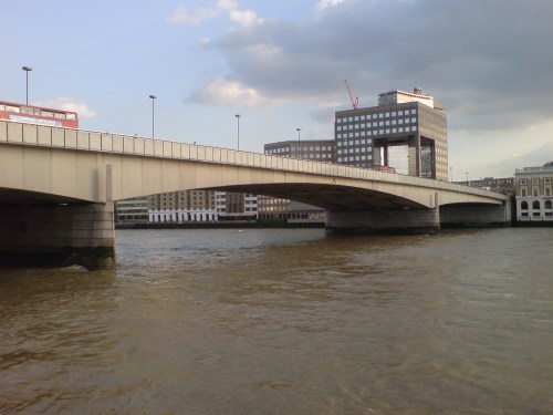
At Westminster Pier, we boarded a Thames Clipper river ferry (Oyster cards gladly accepted) and headed downriver towards Greenwich, passing under London Bridge and the Tower Bridge. (Don’t confuse them. One of my Anglophilic pet peeves is someone referring to the Gothic-spired Tower Bridge as “London Bridge.”)
This is London Bridge.

NOT this. This is Tower Bridge.
London Bridge is pretty nondescript, and it is the third bridge by that name to have occupied that space.
Where London Bridge is currently located is also roughly the same place that the Romans built a bridge when they established the settlement of Londinium in the 1st century A.D. Wooden bridges came and went in that location well into the Middle Ages. The first stone bridge across the Thames connecting London and Southwark was completed in 1209, and remained in place for over six centuries.
“Old London Bridge” was treated like any other street, and had homes and businesses lining either side. A chapel (St. Thomas’s) was next to a small drawbridge in the center which allowed for the passage of some tall ships, but most bigger vessels docked downstream from the bridge. Ferries rowed passengers and cargo through one of nineteen stone arches under the roadway. The heads of traitors could usually be observed impaled on spikes on the bridge’s Southwark entrance.

London Bridge, circa 1600. Those aren’t lollipops on the lower right.
London Bridge was also the site of one of the most epic forgotten battles in history. A huge popular revolt led by Jack Cade rose up against the increasingly disastrous rule of the possibly mentally-challenged Henry VI. Cade’s rebels succceeded in taking over London for a day or two, but were forced out by the Tower of London’s garrison. A huge battle raged on London Bridge all through the night of July 8, 1450. Men fought hand-to-hand by the light of torches and the burning drawbridge until well after sunrise. Several inhabitants of the bridge’s homes were swept up in the fighting, and civilians and combatants alike were sometimes plunged howling into the Thames. When the gates to London were finally heaved closed in the morning light against the pile of charred and bloodied bodies, the revolt collapsed. Jack Cade’s head appeared in the expected spot above the Southwark entrance to the bridge within a few weeks. Political instability continued, ultimately leading to the Wars of the Roses a few years down the road. (I wish I could say I was cool enough to have named my son Cade after this guy, but he was in fact named after now-forgotten UCLA quarterback Cade McNown.)
Over time, the arches grew increasingly narrow due to silt build-up, the river level on either side could vary as much as six feet, and the water gushed through them at low tide like whitewater rapids. “Shooting the bridge” became a test of a boatman’s skill. By the 1500s, the bridge had more than 200 structures on it, some seven stories high. The center road was a mere twelve feet wide, and the top stories of the buildings were extended so far over the road, they almost touched in the middle, creating a tunnel effect.

The bridge’s growing disrepair probably led to the well-known nursery rhyme song. It became so structurally unsound that all of its buildings were torn down in the 1700s, and the bridge itself was finally demolished in 1831.

Out with the old bridge (right), in with the new (left), 1831.
That same year, “New London Bridge” opened, a granite structure with five much-wider arches (and no buildings cluttering it.) By 1896, it was London’s busiest thoroughfare, with 8000 pedestrians and 900 vehicles crossing every hour. But it was gradually sinking into the riverbanks on either side.

New London Bridge
In 1967, it was dismantled…and reassembled in, of all places, Lake Havasu City, Arizona, where it can stare impassively down at thousands of tanned, oblivious spring breakers preening, pissing, screwing, and puking each April.

New London Bridge in its new location, Lake Havasu City, AZ.
The better-engineered modern London Bridge is a perfectly serviceable concrete box-girder bridge, but it has no whiff of romanticism about it and does not draw the eye the way the more impressive Tower Bridge (completed in 1896 and named for the nearby Tower of London) does. It was long rumored that the billionaire entrepreneur Robert McCulloch, who was responsible for buying London Bridge and moving it to Arizona, thought he was getting the Tower Bridge. He always denied this. I think it may be true. (He was from Missouri.)
We got off the ferry at Greenwich, 5½ miles downriver from Charing Cross, and home to the Royal Observatory. This is where time begins, at least as far as we know “time.”
Before we got there, though, there was the matter of an early lunch. Shannon, Cam, and myself were over our jet lag, but our newly-arrived nieces and nephew were in the worst throes of it. They had popped awake and had breakfast around 5:00 that morning, and were now famished. I had partaken in my usual light traveling breakfast (two large cups of strong black coffee and some buttered toast), so I could do with a bite myself. We settled in along long wooden benches on the second floor of Goddards at Greenwich (“Traditional Pie and Mash since 1890”).
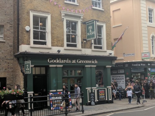
I had the minced beef pie and mash because it seemed to be the specialty of the house, and was a little disappointed. Not the dish’s fault at all, but Shannon’s heartier steak-and-ale pie just looked so much better.

Goddards also seemed very proud of their jellied eels, but all of us skipped those. (Yes, they’re exactly what they sound like. Yes, the bones are still in there.)
In the 1670s, when England was on the rise as a maritime nation, there was a growing need for accurate timekeeping, since accurate timekeeping was vital to determining a ship’s longitude, or position east or west. Latitude (position north or south) had been easy enough to pinpoint for centuries (just measure the angle of the fixed-position North Star relative to the horizon), but longitude required a way to keep precise time while on board a ship. The rolling of a ship on waves plays havoc with a typical clock’s pendulum, and smaller watches had to be constantly wound and measured against a pendulum clock.
Longitude was a very tricky issue, and many ships and their crews were lost because they weren’t sure of their location. Charles II founded a Royal Observatory, administered by an “Astronomer Royal,” to make sure England’s sailors could safely determine their location based on the Observatory’s detailed star charts, created with the aid of increasingly sophisticated telescopes.
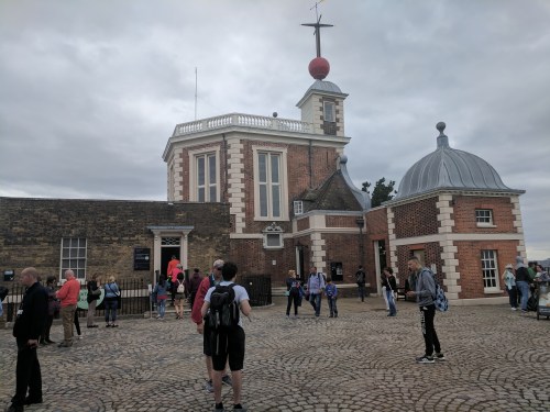
Courtyard of the Royal Observatory, facing the Flamsteed House.
A clockmaker named John Harrison spent thirty years of his life developing a timepiece that could keep time at sea. He finally succeeded with his H4 “sea watch” in the 1760s, and in conjunction with the data generated by the Royal Observatory, the longitude crisis was solved. This bit of history is considered so important, a lavish four-part TV miniseries was made about it in 2000, starring Michael “Professor Dumbledore” Gambon as Harrison. It was called — wait for it — Longitude.
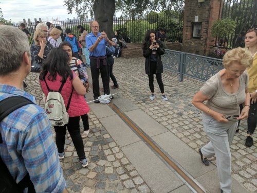
Zero degrees longitude is called the prime meridian. Every seafaring country once determined their own prime meridian, and made their own navigational charts based on it. Increasing globalization caused England’s Prime Meridian (capital P, capital M) at Greenwich to go into universal use after a vote of the International Meridian Conference in 1884 (what a crazy party that must have been). Along with that, the local time in Greenwich became the basis for the international civil time standard, Greenwich Mean Time (GMT).

In keeping with being the home of all standards, the first thing you see when you approach the entrance to the Observatory after a long walk uphill across the broad, green lawns of Greenwich Park is the Public Standards of Length. The yard measured between two brass posts on is the official yard, supposedly based on the distance between Henry I’s (1068-1135) nose and outstretched thumb. The foot is the official foot (supposedly based on — you guessed it — the length of Henry I’s foot.) 19th-century scientists would travel here to make sure their measuring equipment was accurate.

The strip of brass marking the Prime Meridian was close by (on the other side of the gate — pay your admission first, please), and was constantly crowded with people experiencing the novelty of having one foot in the western hemisphere and one foot in the eastern hemisphere.


The Observatory building itself was designed by famous architect Sir Christopher Wren (St. Paul’s cathedral, Kensington Palace, Hampton Court, tons of other stuff) and referred to as the Flamsteed House (after the first Astronomer Royal, John Flamsteed.) It is the first purposely-built scientific research facility in Britain. Most of the actual astronomical observing was farmed out in the mid-20th century (due mainly to light pollution from ever-growing London), leaving the Flamsteed House and its surroundings as museum space. Continue reading
